سبلان: SABALAN: "SabalanFor the Iranian Frigate Sabalan see: Iranian frigate Sabalan.For the depopulated village near Safad see: Sabalan, Safad. Sabalan Mou..."
۱۳۸۹ مهر ۷, چهارشنبه
SABALAN
Sabalan
For the Iranian Frigate Sabalan see: Iranian frigate Sabalan.
For the depopulated village near Safad see: Sabalan, Safad.
Sabalan | |
 | |
4,811 m (15,784 ft) | |
3,283 m (10,771 ft) | |
Location | |
Location | |
Geology | |
5.6–1.4 million years | |
unknown, possibly Holocene | |
Climbing | |
Easiest route | |
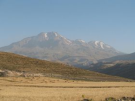
Sabalan (in Persian سبلان Sabalân ;also called Sāvālān in Azerbaijani) is an inactive stratovolcano in Meshkinshahr Ardabil province of northwestern Iran. Sabalan is the third highest mountain in Iran


Contents |
Savalan the Meshkinshahr mountain
Savalan (The Wonder Peak
Located in the extreme north west of Iran Mount Blanc in the Alps . The mountain offers many attractions throughout the year. On the slopes of the mountain the mineral water from springs attracts large amounts of tourists each year, many have faith in healing properties believed to be in the springs. The nomadic people of the area live in small villages, with their round "Yurt" tents appealing to tourism. Savalan is a volcanic peak, and at 3,600 metres you can see gigantic 'sculptures' which are eroded volcanic stone outcrops which resemble animals, birds and insects.
Geology
Savalan is a large andesite stratovolcano, the second highest volcano in Iranian Azerbaijan (North West Iran) after Mount Damavand. The volcano is quite old, as its rocks have been dated to 5.6–1.4 million years. Some references state that volcanic activity continued into the Holocene, less than 10,000 years ago.
The summit region has several peaks exceeding 4,500 metres (14,800 ft), primarily along a southwest-northeast trending ridge. The highest point 4,811 metres (15,784 ft) is at the northeast end of the ridge, and is separated from the 4,620 metres (15,160 ft)+ group of southwestern summits by a 4,190 m (13,750 ft) col.
The mountain is located in a continental climate with hot, dry summers and extremely cold, snowy winters. Precipitation falls primarily as snow in late autumn, winter, and spring, and is sufficient to sustain seven glaciers near the summit above 4,000 metres (13,000 ft). The largest of these were more than 1.5 kilometres (1 mi) in length as of the 1970s. There are also extensive rock glaciers, several of which are more than 3 km (2 mi) in length.
Climbing
The climbing surface includes rocks of various sizes (Class 2 scrambling), and a moderate degree of fitness is required to climb it. The climb from the base camp starts easy, becomes challenging mid way, then eases in gradient near the top. The lake on the top remains frozen except for about four weeks in late July to early August.
Some climbers start by driving to hot springs of Meshkin Shehr, where they start their climb. This climb takes about two days, reaching to the base camp on the first day. Others take a taxi to base camp early in the morning, and climb the mountain in one day. In 2006, there was talk of improving the road to the base camp. If this is done, a regular car should be able to make it to the base camp during the climbing season. The road goes through multiple nomadic encampments of shepherds.
One or two days of acclimatization in Tehran or Ardabil may be advisable. Mountaineering has been popular among the youth in Iran Ardabil . Adequate climbing equipment can be purchased in Ardabil or Tehran

Sabalan from SE, Alvars skiing piste area
Surrounding area
The area around Sabalan, particularly near Meshkin and Dasht-eh Moghan produces large quantities of grain, including wheat. Thanks to the climate produced by the mountain, Ardabil remains pleasantly cool in the summers.
See also
References
- Williams, Richard S., Jr.; Ferrigno, Jane G. (eds.) (1991). Satellite Image Atlas of Glaciers of the World -- Middle East and Africa. USGS Professional Paper 1386-G. pp. 37–39. http://pubs.usgs.gov/pp/p1386g/.
SAVALAN
سبلان (تلفط نام در ترکی آذربایجانی: ساوالان، در تالشی: سفلون)، نام کوهی است مرتفع در شمال غرب کشور ایران و در استان اردبیل.

سبلان سومین قله بلند ایران و یک کوه آتشفشانی غیر فعال است. ارتفاع قله این کوه ۴۸۱۱ متر است و در بالای قله آن دریاچه کوچکی قرار دارد. سبلان به خاطر آبگرمهای طبیعی دامنه کوه، طبیعت تابستانی زیبا و پیست اسکی معروف الوارس مورد توجه گردشگران میباشد.
در جبهه غربی قله سلطان و در کنار جانپناه سنگی به شکل عقاب به نام قارتال (در ترکی آذربایجانی به معنی عقاب) قراردارد که در طول زمان به نماد سبلان تبدیل شدهاست.این قطعه سنگ به شکل عقابی است که نشسته و سر را به جانب شرق چرخانده است.
کوه سبلان در شمال شرقی و در ۲۵ کیلومتری جنوب شرقی مشگینشهر واقع است. این کوه در طول جغرافیایی ۴۷ درجه و ۵۰ دقیقه شرقی و عرض جغرافیایی ۳۸درجه و ۱۷دقیقه شمالی قرار گرفتهاست. برای این کوه عظیم ۶۰ کیلومتر طول و ۴۵ کیلومتر پهنا تخمین میزنند و سطحی که به وسیله آن در آذربایجان قرار گرفته نزدیک به ۶۰۰۰ کیلومتر مربع است.
کوهستان سبلان به طور کلی سه قله معروف دارد قله بزرگ آن به سلطان مشهور است و دو قله دیگر آن به هرم و کسری مشهورند.
کوه سبلان از مجموعهای از ارتفاعات متعدد تشکیل شده که به موازات ارسباران ولی اندکی در شرق آن کشیده شدهاست.
امتداد آن شرقی – غربی است و از شرق و شمال و جنوب کوهی به نام قوشه داغ آنرا به رشته کوه ارسباران متصل میکند. در جنوب آن کوه بزگوش (بزغوش)، که از سمت جنوب غربی به کوهستان سهند مربوط است – کشیده شدهاست.
قسمت شرقی کوه سبلان به قله آتشفشان سبلان که در بلندای ۴۸۱۱ متری قرار دارد منتهی میشود. در قله آن دریاچهای به چشم میخورد، تمام قلههای سبلان در ایام سال پوشیده از یخ و برفهای دائمی است.
کوهنوردی

دریاچه بالای قله سبلان، تیم کوهنوردی از ایران و صربستان
صعود به قله سبلان از جبهه اصلی (شمالی) ساده بوده و کوهنوردان معمولی به راحتی صعود تابستانه را در چند ساعت (صبح تا ظهر) انجام میدهند. جبهه جنوبی سختترین راه صعود به این قله میباشد که از سنگهای بزرگ تشکیل شدهاست. پیست اسکی آلوارس که یکی از مجهزترین پیستهای اسکی ایران است در این مسیر قرار دارد.


منبع
- اطلس گیتاشناسی استانهای ایران، تهران: ۱۳۸۳.
- نوبختی خیاوی؛ سلیمان، خیاو، گمشدهٔ تاریخ، تهران: نشر قو، ۱۳۸۰، ص۱۷.
عکسهای ماهوارهای
عکسهای ماهوارهای


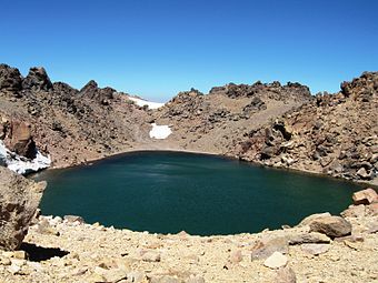 دریاچه دهانه سبلان
۱۳۸۹ مهر ۴, یکشنبه
سبلان
این وبلاگ برای معروفی طبیعت بکر سبلان ایجاد شده و مطالب علمی پژوهشی و در مور طبیعت و بوم شناختی و کشاورزی در آن درج خواهد شد
اشتراک در:
پستها (Atom)